
Monitoring and Modeling the Rapid Evolution of Earth's Newest Volcanic Island: Hunga Tonga Hunga Ha'apai (Tonga) Using High Spatial Resolution Satellite Observations
Abstract
We have monitored a newly erupted volcanic island in the Kingdom of Tonga, unofficially known as Hunga Tonga Hunga Ha'apai, by means of relatively frequent high spatial resolution (~50 cm) satellite observations. The new ~1.8 km2 island formed as a tuff cone over the course of a month-long hydromagmatic eruption in early 2015 in the Tonga-Kermadec volcanic arc. Such ash-dominated eruptions usually produce fragile subaerial landscapes that wash away rapidly due to marine erosion, as occurred nearby in 2009. Our measured rates of erosion are ~0.00256 km3/year from derived digital topographic models. Preliminary measurements of the topographic expression of the primary tuff cone over ~30 months suggest a lifetime of ~19 years (and potentially up to 42 years). The ability to measure details of a young island's landscape evolution using satellite remote sensing has not previously been possible at these spatial and temporal resolutions.
- Authors:
-
 [1];
[1];
[2];
[4];
[5]
[1];
[1];
[2];
[4];
[5]
- NASA Goddard Space Flight Center (GSFC), Greenbelt, MD (United States)
- Columbia Univ., Palisades, NY (United States)
- Canadian Space Agency, Saint‐Hubert, Quebec (Canada)
- Pacific Northwest National Lab. (PNNL), Richland, WA (United States); Univ. of Maryland, College Park, MD (United States)
- Earth System Science Interdisciplinary Center (ESSIC/UMD), College Park, MD (United States)
- Publication Date:
- Research Org.:
- Pacific Northwest National Lab. (PNNL), Richland, WA (United States)
- Sponsoring Org.:
- USDOE
- OSTI Identifier:
- 1438984
- Report Number(s):
- PNNL-SA-131017
Journal ID: ISSN 0094-8276
- Grant/Contract Number:
- AC05-76RL01830
- Resource Type:
- Accepted Manuscript
- Journal Name:
- Geophysical Research Letters
- Additional Journal Information:
- Journal Volume: 45; Journal Issue: 8; Journal ID: ISSN 0094-8276
- Publisher:
- American Geophysical Union
- Country of Publication:
- United States
- Language:
- English
- Subject:
- 58 GEOSCIENCES; 47 OTHER INSTRUMENTATION; surtseyan eruption; Tonga; Hunga Tonga Hunga Ha'apai; very high-resolution satellite imagery; volcanism; remote sensing
Citation Formats
                    Garvin, J. B., Slayback, D. A., Ferrini, V., Frawley, J., Giguere, C., Asrar, G. R., and Andersen, K. Monitoring and Modeling the Rapid Evolution of Earth's Newest Volcanic Island: Hunga Tonga Hunga Ha'apai (Tonga) Using High Spatial Resolution Satellite Observations.  United States: N. p., 2018.
Web.  doi:10.1002/2017GL076621.
Garvin, J. B., Slayback, D. A., Ferrini, V., Frawley, J., Giguere, C., Asrar, G. R., & Andersen, K. Monitoring and Modeling the Rapid Evolution of Earth's Newest Volcanic Island: Hunga Tonga Hunga Ha'apai (Tonga) Using High Spatial Resolution Satellite Observations. United States. https://doi.org/10.1002/2017GL076621
                    Garvin, J. B., Slayback, D. A., Ferrini, V., Frawley, J., Giguere, C., Asrar, G. R., and Andersen, K. Sat .
"Monitoring and Modeling the Rapid Evolution of Earth's Newest Volcanic Island: Hunga Tonga Hunga Ha'apai (Tonga) Using High Spatial Resolution Satellite Observations".  United States.  https://doi.org/10.1002/2017GL076621.  https://www.osti.gov/servlets/purl/1438984.
@article{osti_1438984,

  title        = {Monitoring and Modeling the Rapid Evolution of Earth's Newest Volcanic Island: Hunga Tonga Hunga Ha'apai (Tonga) Using High Spatial Resolution Satellite Observations},

  author       = {Garvin, J. B. and Slayback, D. A. and Ferrini, V. and Frawley, J. and Giguere, C. and Asrar, G. R. and Andersen, K.},

  abstractNote = {We have monitored a newly erupted volcanic island in the Kingdom of Tonga, unofficially known as Hunga Tonga Hunga Ha'apai, by means of relatively frequent high spatial resolution (~50 cm) satellite observations. The new ~1.8 km2 island formed as a tuff cone over the course of a month-long hydromagmatic eruption in early 2015 in the Tonga-Kermadec volcanic arc. Such ash-dominated eruptions usually produce fragile subaerial landscapes that wash away rapidly due to marine erosion, as occurred nearby in 2009. Our measured rates of erosion are ~0.00256 km3/year from derived digital topographic models. Preliminary measurements of the topographic expression of the primary tuff cone over ~30 months suggest a lifetime of ~19 years (and potentially up to 42 years). The ability to measure details of a young island's landscape evolution using satellite remote sensing has not previously been possible at these spatial and temporal resolutions.},

  doi          = {10.1002/2017GL076621},

  journal      = {Geophysical Research Letters},

  number       = 8,

  volume       = 45,

  place        = {United States},

  year         = {Sat Apr 28 00:00:00 EDT 2018},

  month        = {Sat Apr 28 00:00:00 EDT 2018}

}
 Search WorldCat to find libraries that may hold this journal
Web of Science
Figures / Tables:
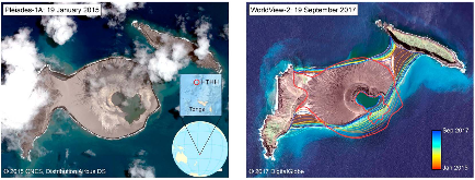 Figure 1: The Airbus Pléiades-1A image (left) at the end of the eruptive stage (19 January 2015). This is the initial, preerosional expression of the new island (Hunga Tonga Hunga Ha’apai) with an inset showing its location (red circle). The current state of the island 2.75 years later (right) ismore »
Works referenced in this record:
Coastal evolution on volcanic oceanic islands: A complex interplay between volcanism, erosion, sedimentation, sea-level change and biogenic production
journal, December 2013
- Ramalho, Ricardo S.; Quartau, Rui; Trenhaile, Alan S.
- Earth-Science Reviews, Vol. 127
Satellite observations of a surtseyan eruption: Hunga Ha'apai, Tonga
journal, December 2010
- Vaughan, R. Greg; Webley, Peter W.
- Journal of Volcanology and Geothermal Research, Vol. 198, Issue 1-2
Hydrovolcanic explosions; II, Evolution of basaltic tuff rings and tuff cones
journal, May 1983
- Wohletz, K. H.; Sheridan, M. F.
- American Journal of Science, Vol. 283, Issue 5
Climate and the Pace of Erosional Landscape Evolution
journal, August 2017
- Perron, J. Taylor
- Annual Review of Earth and Planetary Sciences, Vol. 45, Issue 1
Determination of geomorphological and volumetric variations in the 1970 land volcanic craters area (Deception Island, Antarctica) from 1968 using historical and current maps, remote sensing and GNSS
journal, March 2012
- Berrocoso, M.; Torrecillas, C.; Jigena, B.
- Antarctic Science, Vol. 24, Issue 4
Geology, petrography, and geochemistry of the volcanic islands of Tonga
journal, March 1972
- Bryan, W. B.; Stice, G. D.; Ewart, A.
- Journal of Geophysical Research, Vol. 77, Issue 8
Hydrovolcanic tuff rings and cones as indicators for phreatomagmatic explosive eruptions on Mars: PHREATOMAGMATIC ERUPTIONS ON MARS
journal, August 2013
- Brož, P.; Hauber, E.
- Journal of Geophysical Research: Planets, Vol. 118, Issue 8
Pyroclastic rocks
journal, April 1985
- Heiken, Grant
- Geochimica et Cosmochimica Acta, Vol. 49, Issue 4
Pyroclastic Rocks
journal, October 1985
- McBirney, Alexander R.
- Journal of Volcanology and Geothermal Research, Vol. 26, Issue 1-2
Bathymetry grid of Hung Tonga-Hunga Ha'apai Volcano generated from data acquired during Falkor cruise FK160407 (2016)
dataset, January 2022
- Ferrini, Vicki
- Interdisciplinary Earth Data Alliance (IEDA)
Works referencing / citing this record:
Coral reef annihilation, persistence and recovery at Earth’s youngest volcanic island
journal, December 2019
- Smallhorn-West, P. F.; Garvin, J. B.; Slayback, D. A.
- Coral Reefs, Vol. 39, Issue 3
Diversity of soluble salt concentrations on volcanic ash aggregates from a variety of eruption types and deposits
journal, June 2019
- Colombier, Mathieu; Mueller, Sebastian B.; Kueppers, Ulrich
- Bulletin of Volcanology, Vol. 81, Issue 7
Figures / Tables found in this record: