U.S. Department of Energy
Office of Scientific and Technical Information

Model Evaluation by Measurements from Collocated Remote Sensors in Complex Terrain

Journal Article · · Weather and Forecasting
 [1];  [1];  [2];  [1];  [2];  [2];  [2];  [1];  [3];  [4];  [5]
  1. University of Colorado, Boulder, CO (United States); National Oceanic and Atmospheric Administration (NOAA), Boulder, CO (United States)
  2. National Oceanic and Atmospheric Administration (NOAA), Boulder, CO (United States)
  3. National Renewable Energy Laboratory (NREL), Golden, CO (United States); University of Colorado, Boulder, CO (United States)
  4. Pacific Northwest National Laboratory (PNNL), Richland, WA (United States)
  5. Lawrence Livermore National Laboratory (LLNL), Livermore, CA (United States)

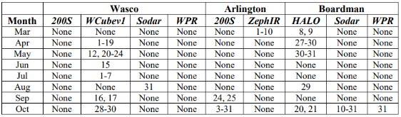
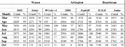
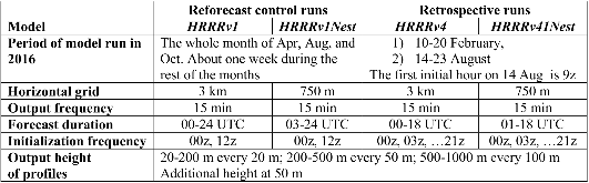
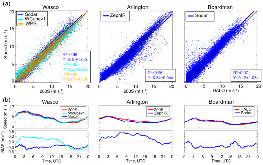
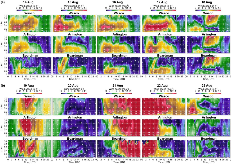
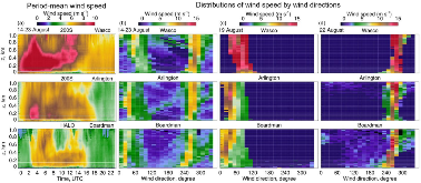
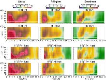
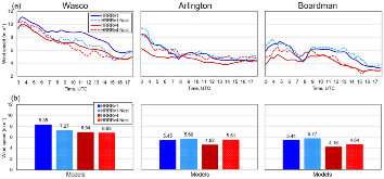
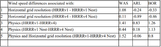
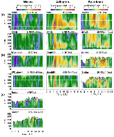
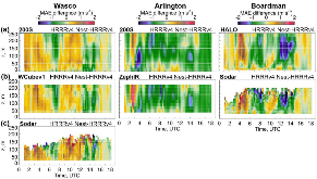
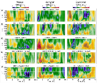
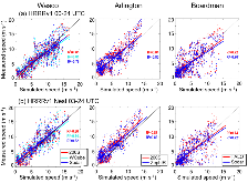
Model improvement efforts involve an evaluation of changes in model skill in response to changes in model physics and parameterization. When using wind measurements from various remote sensors to determine model forecast accuracy, it is important to understand the effects of measurement-uncertainty differences among the sensors resulting from differences in the methods of measurement, the vertical and temporal resolution of the measurements, and the spatial variability of these differences. Here we quantify instrument measurement variability in 80-m wind speed during WFIP2 and its impact on the calculated errors and the change in error from one model version to another. Here the model versions tested involved updates in model physics from HRRRv1 to HRRRv4, and reductions in grid interval from 3 km to 750 m. Model errors were found to be 2–3 m s–1. Differences in errors as determined by various instruments at each site amounted to about 10% of this value, or 0.2–0.3 m s–1. Changes in model skill due to physics or grid-resolution updates also differed depending on the instrument used to determine the errors; most of the instrument-to-instrument differences were ~0.1 m s–1, but some reached 0.3 m s–1. All instruments at a given site mostly showed consistency in the sign of the change in error. In two examples, though, the sign changed, illustrating a consequence of differences in measurements: errors determined using one instrument may show improvement in model skill, whereas errors determined using another instrument may indicate degradation. This possibility underscores the importance of having accurate measurements to determine the model error.

Research Organization:
Pacific Northwest National Laboratory (PNNL), Richland, WA (United States); National Renewable Energy Laboratory (NREL), Golden, CO (United States); Lawrence Livermore National Laboratory (LLNL), Livermore, CA (United States)
Sponsoring Organization:
USDOE Office of Energy Efficiency and Renewable Energy (EERE), Renewable Power Office. Wind Energy Technologies Office; National Oceanic and Atmospheric Administration (NOAA)
Grant/Contract Number:
AC05-76RL01830; AC36-08GO28308; AC52-07NA27344
OSTI ID:
1895367
Alternate ID(s):
OSTI ID: 1899960
OSTI ID: 2281473
Report Number(s):
PNNL-SA--175552; NREL/JA--5000-83549; LLNL--JRNL-858942
Journal Information:
Weather and Forecasting, Journal Name: Weather and Forecasting Journal Issue: 10 Vol. 37; ISSN 0882-8156
Publisher:
American Meteorological SocietyCopyright Statement
Country of Publication:
United States
Language:
English

References (34)

The Effect of Wind-Turbine Wakes on Summertime US Midwest Atmospheric Wind Profiles as Observed with Ground-Based Doppler Lidar journal July 2013
The Plio-Quaternary uplift of the Apennine chain: new data from the analysis of topography and river valleys in Central Italy journal November 2008
Measuring turbine inflow with vertically-profiling lidar in complex terrain journal July 2015
Nocturnal Low-Level Jet Characteristics Over Kansas During Cases-99 journal November 2002
Evaluating the WFIP2 updates to the HRRR model using scanning Doppler lidar measurements in the complex terrain of the Columbia River Basin journal July 2020
Detection of Range-Folded Returns in Doppler Lidar Observations journal April 2017
Conically scanning lidar error in complex terrain [Conically scanning lidar error in complex terrain] journal May 2009
The Onshore Surge of Marine Air into the Pacific Northwest: A Coastal Region of Complex Terrain journal December 1986
Horizontal-Velocity and Variance Measurements in the Stable Boundary Layer Using Doppler Lidar: Sensitivity to Averaging Procedures journal August 2008
Columbia Gorge Gap Winds: Their Climatological Influence and Synoptic Evolution journal December 2004
COLUMBIA GORGE GAP FLOW: Insights from Observational Analysis and Ultra-High-Resolution Simulation journal December 2002
Wind Energy Meteorology: Insight into Wind Properties in the Turbine-Rotor Layer of the Atmosphere from High-Resolution Doppler Lidar journal June 2013
The Second Wind Forecast Improvement Project (WFIP2): Observational Field Campaign journal September 2019
The Second Wind Forecast Improvement Project (WFIP2): General Overview journal September 2019
Improving Wind Energy Forecasting through Numerical Weather Prediction Model Development journal November 2019
Spatial Variability of Winds and HRRR–NCEP Model Error Statistics at Three Doppler-Lidar Sites in the Wind-Energy Generation Region of the Columbia River Basin journal August 2019
Identification and Characterization of Persistent Cold Pool Events from Temperature and Wind Profilers in the Columbia River Basin journal December 2019
Performance of a Wind-Profiling Lidar in the Region of Wind Turbine Rotor Disks journal March 2012
A North American Hourly Assimilation and Model Forecast Cycle: The Rapid Refresh journal April 2016
Characterizing NWP Model Errors Using Doppler-Lidar Measurements of Recurrent Regional Diurnal Flows: Marine-Air Intrusions into the Columbia River Basin journal February 2020
The High-Resolution Rapid Refresh (HRRR): An Hourly Updating Convection-Allowing Forecast Model. Part II: Forecast Performance journal August 2022
Lidar - LLNL ZephIR Profiler, Arlington Airport - Reviewed Data dataset January 2021
Sodar - ARL Wind Profiler, Wasco Airport - Reviewed Data
  • Richard, Eckman; Brad, Reese
  • Atmosphere to Electrons (A2e) Data Archive and Portal, Pacific Northwest National Laboratory; PNNL https://doi.org/10.21947/1356333
dataset January 2020
Sodar - ARL Wind Profiler, Boardman - Reviewed Data
  • Richard, Eckman; Brad, Reese
  • Atmosphere to Electrons (A2e) Data Archive and Portal, Pacific Northwest National Laboratory; PNNL https://doi.org/10.21947/1356340
dataset January 2021
Lidar - ND Halo Scanning Doppler, Boardman - Reviewed Data
  • Fernando, Joe; Leo, Laura; Raghavendra, Krishnamurthy
  • Atmosphere to Electrons (A2e) Data Archive and Portal, Pacific Northwest National Laboratory; PNNL https://doi.org/10.21947/1402036
dataset January 2021
Radar - ESRL Wind Profiler with RASS, Wasco Airport - Reviewed Data dataset January 2021
Radar - ARL Wind Profilerwith RASS, Boardman - Reviewed Data dataset January 2021
Lidar - ESRL WindCube 200s, Wasco Airport - Reviewed Data
  • Baidar, Sunil; Brewer, Alan
  • Atmosphere to Electrons (A2e) Data Archive and Portal, Pacific Northwest National Laboratory; PNNL https://doi.org/10.21947/1418023
dataset January 2021
Lidar - ESRL WindCube 200s, Arlington Airport - Reviewed Data
  • Brewer, Alan; Baidar, Sunil
  • Atmosphere to Electrons (A2e) Data Archive and Portal, Pacific Northwest National Laboratory; PNNL https://doi.org/10.21947/1418024
dataset January 2021
Spatial and temporal variability of turbulence dissipation rate in complex terrain journal January 2019
Evaluation of turbulence measurement techniques from a single Doppler lidar journal January 2017
Quantifying error of lidar and sodar Doppler beam swinging measurements of wind turbine wakes using computational fluid dynamics journal January 2015
Impact of model improvements on 80 m wind speeds during the second Wind Forecast Improvement Project (WFIP2) journal January 2019
Mountain waves can impact wind power generation journal January 2021

Figures / Tables (20)