Mid-latitude ionospheric irregularity spectral density as determined by ground-based GPS receiver networks
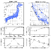
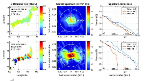
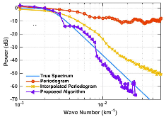
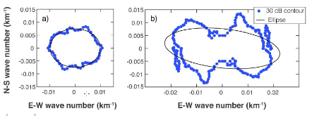
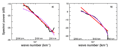
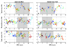
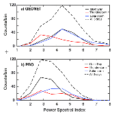
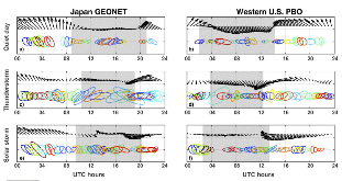
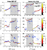
Abstract We present a new technique to experimentally measure the spatial spectrum of ionospheric disturbances in the spatial scale regime of 40–200 km. This technique produces a two‐dimensional (2‐D) spectrum for each time snapshot over two dense Global Positioning System (GPS) receiver networks (GPS Earth Observation Network in Japan and Plate Boundary Observatory in the Western United States). Because this technique created the spectrum from an instantaneous time snapshot, no assumptions are needed about the speed of ionospheric irregularities. We examine spectra from 3 days: one with an intense geomagnetic storm, one with significant lightning activity, and one quiet day. Radial slices along the 2‐D spectra provide one‐dimensional spectra that can be fit to a power law to quantify the steepness of the falloff in the spatial scale sizes. Continuous data of this type in a stationary location allow monitoring the variability in the 2‐D spectrum over the course of a day and comparing between days, as shown here, or even over a year or many years. We find that the spectra are highly variable over the course of a day and between the two selected regions of Japan and the Western United States. When strong traveling ionospheric disturbances (TIDs) are present, the 2‐D spectra provide information about the direction of propagation of the TIDs. We compare the TID propagation direction with horizontal wind directions from the Horizontal Wind Model. TID direction is correlated with the horizontal wind direction on all days, strongly indicating that the primary source of the TIDs measured by this technique is tropospheric.
- Research Organization:
- Los Alamos National Laboratory (LANL), Los Alamos, NM (United States)
- Sponsoring Organization:
- USDOE Laboratory Directed Research and Development (LDRD) Program
- Grant/Contract Number:
- AC52-06NA25396
- OSTI ID:
- 1440449
- Alternate ID(s):
- OSTI ID: 1441015
- Report Number(s):
- LA-UR-18-21184; TRN: US1900738
- Journal Information:
- Journal of Geophysical Research. Space Physics, Vol. 123, Issue 6; ISSN 2169-9380
- Publisher:
- American Geophysical UnionCopyright Statement
- Country of Publication:
- United States
- Language:
- English
Web of Science
Similar Records
Results from the northern New Mexico satellite-beacon radio interferometer
Global inospheric effects of the October 1989 geomagnetic storm