Application of Gauss's theorem to quantify localized surface emissions from airborne measurements of wind and trace gases
- Univ. of California, Davis, CA (United States). Department of Land, Air, & Water Resources; Scientific Aviation, Inc., Boulder, CO (United States)
- Univ. of California, Davis, CA (United States). Department of Land, Air, & Water Resources
- National Center for Atmospheric Research, Boulder, CO (United States). Mesoscale and Microscale Meteorology Laboratory
- University of Colorado, Boulder, CO (United States). Cooperative Institute for Research in Environmental Sciences
- Aerodyne Research, Inc, Billerica, MA (United States)
- University of Colorado, Boulder, CO (United States). Cooperative Institute for Research in Environmental Sciences; NOAA Earth System Research Laboratory, Boulder, CO (United States)
- Scientific Aviation, Inc., Boulder, CO (United States)
- Univ. of Michigan, Ann Arbor, MI (United States). Climate and Space Sciences and Engineering
- NOAA Earth System Research Laboratory, Boulder, CO (United States)
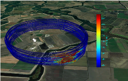
Airborne estimates of greenhouse gas emissions are becoming more prevalent with the advent of rapid commercial development of trace gas instrumentation featuring increased measurement accuracy, precision, and frequency, and the swelling interest in the verification of current emission inventories. Multiple airborne studies have indicated that emission inventories may underestimate some hydrocarbon emission sources in US oil- and gas-producing basins. Consequently, a proper assessment of the accuracy of these airborne methods is crucial to interpreting the meaning of such discrepancies. We present a new method of sampling surface sources of any trace gas for which fast and precise measurements can be made and apply it to methane, ethane, and carbon dioxide on spatial scales of ~1000 m, where consecutive loops are flown around a targeted source region at multiple altitudes. Using Reynolds decomposition for the scalar concentrations, along with Gauss's theorem, we show that the method accurately accounts for the smaller-scale turbulent dispersion of the local plume, which is often ignored in other average mass balance methods. With the help of large eddy simulations (LES) we further show how the circling radius can be optimized for the micrometeorological conditions encountered during any flight. Furthermore, by sampling controlled releases of methane and ethane on the ground we can ascertain that the accuracy of the method, in appropriate meteorological conditions, is often better than 10 %, with limits of detection below 5 kg h-1 for both methane and ethane. Because of the FAA-mandated minimum flight safe altitude of 150 m, placement of the aircraft is critical to preventing a large portion of the emission plume from flowing underneath the lowest aircraft sampling altitude, which is generally the leading source of uncertainty in these measurements. Finally, we show how the accuracy of the method is strongly dependent on the number of sampling loops and/or time spent sampling the source plume.
- Research Organization:
- Research Partnership to Secure Energy for America, Houston TX (United States)
- Sponsoring Organization:
- USDOE
- Grant/Contract Number:
- AC26-07NT42677
- OSTI ID:
- 1424733
- Journal Information:
- Atmospheric Measurement Techniques (Online), Vol. 10, Issue 9; ISSN 1867-8548
- Publisher:
- European Geosciences UnionCopyright Statement
- Country of Publication:
- United States
- Language:
- English
Web of Science


Similar Records
Airborne flux measurements of ammonia over the Southern Great Plains using chemical ionization mass spectrometry
Airborne flux measurements of ammonia over the southern Great Plains using chemical ionization mass spectrometry