

SPRUCE Representing Northern Peatland Microtopography and Hydrology within the Community Land Model: Modeling Archive
Description
Here we provide model code, inputs, outputs and evaluation datasets for a new configuration of the Community Land Model (CLM) for SPRUCE, which includes a fully prognostic water table calculation for SPRUCE.
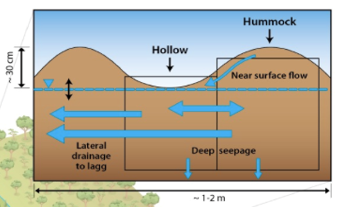
Our structural and process changes to CLM focus on modifications needed to represent the hydrologic cycle of bogs environment with perched water tables, as well as distinct hydrologic dynamics and vegetation communities of the raised hummock and sunken hollow microtopography characteristic of SPRUCE and other peatland bogs. The modified model was parameterized and independently evaluated against observations from an ombrotrophic raised-dome bog in northern Minnesota (S1-Bog), the site for the Spruce and Peatland Responses Under Climatic and Environmental Change experiment (SPRUCE).
Citation
Shi, X., Thornton, P. E., Ricciuto, D. M., Hanson, P. J., Mao, J., Sebestyen, S. D., Griffiths, N. A., and Bisht, G. 2016. SPRUCE Representing Northern Peatland Microtopography and Hydrology within the Community Land Model: Modeling Archive. Carbon Dioxide Information Analysis Center, Oak Ridge National Laboratory, U.S. Department of Energy, Oak Ridge, Tennessee, U.S.A. http://dx.doi.org/10.3334/CDIAC/spruce.031
Download
Posted
Tuesday, September 6, 2016
SPRUCE ID: spruce.031
Public
Click image to see full-sized version

